| Commencing at the Base
Line, at intervals of six miles, lines are run East and West parallel with
the Base Line. These are designated as Township Lines. They
divide the land into strips or divisions six miles wide, extending East
and West parallel with the Base Line. This plan is followed both
North and South of the Base Line until the territory governed by another
Principal Meridian and Base Line is reached. These divisions or Townships
are numbered from one upward, both North and South of the Base Line, and
their numbers are indicated by figures. For instance: The first
sex mile division North of the Base Line is Township 1 North; the
next is Township 2 North; then comes Township 3, 4, 5 and 6, North,
and so on. The same plan is followed South of the Base Line;
the Townships being designated as Township 1 South, Township 2 South, and
so on. The "North" or "South" (the initials N. or S. being generally
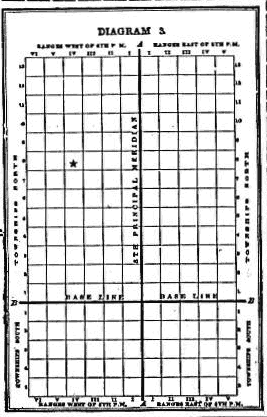
used) indicates the direction from the Base Line. See Diagram 3.
These Township and Range Lines, Crossing each
other, as shown in Diagram 3, form squares, which are called "Townships"
or Goverment Townships" which are six miles square, or as nearly that as
it is possible to make them. These Townships are a very important
feature in locating or describing a piece of land. The location of
a Goverment Township, however, is very readily found when the number of
the Township and Range is given, by merely counting the number indicated
from the Base Line and Principal Meridian. As an example of this,
Township 8 North, Range 4, West of the 5th Principal Meridian, is at once
located on the square marked  on Diagram 3, by counting eight tiers north of the Base Line and 4 tiers
west of the Meridian.
on Diagram 3, by counting eight tiers north of the Base Line and 4 tiers
west of the Meridian. |
|