FRACTIONAL PIECES OF LAND
 

Congressional Townships vary considerably as to size and boundaries.  Mistakes made in surveying and the fact that Meridians converge as they run North cause every Township to vary more or less from the 23,400 acres which a perfect Township would contain.  See Diagram 4.  In arranging a Township into Sections all the surplus or deficiency of land is given to, or taken from, the North and West tiers of Sections.  In other words, all Sections in the Township are made full - 640 acres - except those on the North and West, which are given all the land that is left after forming the other 25 sections.
 
Diagram 4 illustrates how the surplus or deficiency is distributed and the Sections it affects.  It will be seen that Sections 1, 2, 3, 4, 5, 6, 7, 18, 19, 30 and 31, are the "Fractional Sections," or the Sections which are affected if the Township overruns or falls short.  Inside of these Fractional Sections, all of the surplus or deficiency of land (over or under 640 acres) is carried to the "forties" or "eighties" that touch the Township Line.  These pieces of land are called "Fractional Forties" or Fractional Eighties: as the case may be.  Diagrams 4 and 6 show the manner of marking the acreage and outlining the boundaries of these "Fractions." 

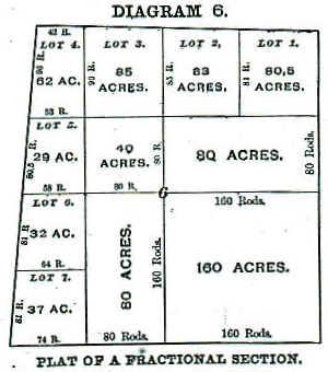
Diagram 6 illustrates how the surplus or deficiency of land inside of these Sections is distributed and which "forties" or "eighties" it affects.  From this arrangement it will be seen that in any Section that touches the North or West Township Lines, the Southeast Quarter may be full - 160 acres - while another quarter of the same Section may be much larger or smaller.  Frequently these fractional "forties" or "eighties" are lotted as shown in Diagram 6.  They are always described as fractional tracts of land, as the "fractional S.W. 1/4 of Section 6," etc.  Of course those portions of these Sections which are not affected by these variations are described in the usual manner - as Southeast 1/4 of Section 6.  As a rule Townships are narrower at the North than at the South side.  The Meridians of Longitude (which run North and South) converge as they run North and South from the Equator.  They begin at the Equator with a definite width between them and gradually converge until they all meet at the poles.Now, as the Range lines are run North and South, it will at once be seen that  the convergence of Meridians will cause every Congressional Township (North of the Equator) to be narrower at its North than at its South side, as stated. See Diagram 4.

In addition to this fact, mistakes of measurement are constantly and almost unavoidably made in running both Township and Range lines, and if no new starting points were established the lines would become confused and unreliable, and the size and shape of Townships materially affected by the time the surveys had extended even a hundred miles from the Base Line and Principal Meridian,  In order to correct they surveys and variations caused by the difference of latitude and straighten the lines, "Correction Lines" (or Guide Meridians and Standard Parallels) are established at frequent intervals, usually as follows:  North of the Base Line a Correction Line is run East and West parallel with the Base Line, usually every twenty-four miles.  South of the Base Line a Correction Line is usually established every thirty miles. Both East and West of the Principal Meridian "Correction Lines" are usually established every 48 miles.  All Correction Lines are located by careful measurement, and the succeeding surveys are based upon them.


Source: Plat Book of Clinton County, Illinois. Compiled and Published by The Occidental Publishing Company, Geo. A. Ogle &
Company, Proprs., Chicago, 1892 which included the plats and the business directory


 Plat Township Lists
 
Clinton County Genealogy