|
|
1875 Clinton County MapSource: "Atlas of Henry Co. Illinois to Which is Added an Atlas of the United States," Warner & Beers Publishers, Chicago, 1875. Submitted by Alice Gless |
|
|
|
1875 Clinton County MapSource: "Atlas of Henry Co. Illinois to Which is Added an Atlas of the United States," Warner & Beers Publishers, Chicago, 1875. Submitted by Alice Gless |
|
| View
complete 1875 Map of Clinton
(396KB)
OR For faster loading, click the colored township areas below to bring up smaller maps. |
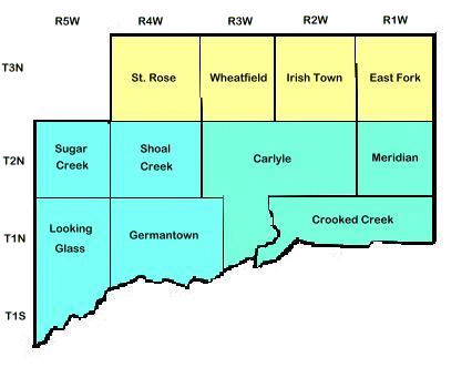 |
What do you do with these maps? First visit Illinois Public Domain Land Tract Sales
(Clinton is county 14 here) OR The Bureau
of Land Management and do a search on your
surnames. For instance - I looked up the name John Scott and found it listed as Township 2N (T2N), Range 2W (R2W) Section 16. Now I find the point where T2N & R2W intersect (Carlyle), view the plat map for that section and walla, that little square with the number 16 on it in Carlyle Township is the land bought by John Scott. |
The above map is what Clinton County looked like in 1875. By 1892 Clinton county divided up into even more sections. Please visit our 1892 Plat Map Page for a more detailed map.
This file last modified
