Read by Louis and Linda Holthaus, Gloria Dettleff and Dorothy Falk on 19 Jan 2006
If you know of additional people that were buried here, please Contact Us.
This cemetery is about 1 block south of the Lowe and Pelican Roads junction in Section 2 on the Bergmann property. It was previously known as the Zachary property. Ask permission to visit the cemetery at the house up the hill by the red barn. After you walk over the dam, the cemetery is to the right in what used to be a little clearing but is now overrun with saplings, sticker bushes and years of dropped foliage. The cemetery was not affected by the creation of the farm lake.
The cemetery is among the oldest that we've seen and the only stones that we found, except for the Government marker, were buried under about 3 or 4 inches of dirt, leaves and roots. There were several markers, mostly broken and buried, dotted here and there throughout the possible-half-acre area.
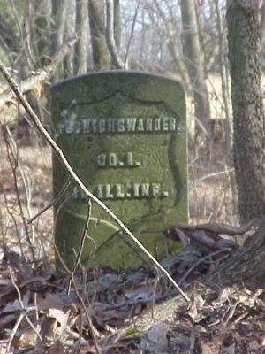
When we arrived, the Henry Sharp 1812 marker was in front of the J. Nighswander Civil War marker, both next to a tree. We moved Henry's 1812 marker to an area near his wife Rhoda's grave where there is a large broken unmarked buried limestone marker, which could be for his grave. We did not return the dirt on top of the graves since we think a family member will visit there this summer.
If there is an article about the ceremony when the marker was placed there, perhaps would be a get a firm location for his grave.
You may want to contact Becky Sharp McCormack, a SHARP researcher.
* are items from previous readings by Helen Sharp Wickcliffe and by Ruth Nighswander Riggs.

